1523 14th St. West, Ste. 2
Billings, MT 59102
Mailing Address:
P.O. Box 23535
Billings, MT 59104

Visiting the Pillar
Hours of Operation:
From October 1st through April 30th Pompeys Pillar is closed.
The Main Gate is open May 1st through September 30th from 8:30am to 4:30pm seven days a week.
The Interpretive Center is open May 1st through September 30th from 9AM to 4PM.
Even when the Monument is closed, visitors may still walk into the site during daylight hours. The walk from the gates to the Pillar is about 3/4 mile. Special arrangements can be made during the off-season for school programs and other special events.
Private Vehicle Standard Fees
Rates are based on number of passengers.
- 1-6 passengers–$7.50
- 7-25 passengers–$13
- 26+ passengers–$22
Commercial/Group Vehicle Fees
- Commercial group rates are based on vehicle capacity.
- Vehicles capable of seating 6 passengers and under–$25
- Vehicles capable of seating 7-25 passengers–$40
- Vehicles capable of seating 26+ passengers–$100
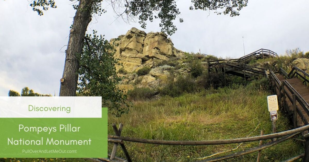
Boardwalk
The boardwalk up the Pillar leads to Clark’s signature and continues to the top of mesa. It is approximately 1,000 feet long and contains about 200 steps.
Day Use Area
The day use area is ideal for picnicking or relaxing. It is adjacent to the Yellowstone River and shaded by large cottonwood trees.
Accessibility
The interpretive center, restrooms, parking lot, and day use area are fully accessible.
Pets
Pets must be on a leash at all times.
Interpretive Center
The Pompeys Pillar Interpretive Center opened in 2006. Exhibits in the 5,700-square foot center relate the journey of Captain William Clark and his detachment, including Sacagawea and her son Pomp, down the Yellowstone River Valley in 1806. The center also addresses native culture, flora and fauna, the Lewis and Clark Expedition, and the historical legacy of Pompeys Pillar through the changes of the 1800s. A number of J.K. Ralston paintings and sketches are on permanent display.
Natural and Cultural Resources
Please respect our heritage and treat the Monument and its resources with respect. Do not deface any tree, shrub, rock, or ancient Indian artifact. Do not touch petroglyphs or remove any artifact. Not only is this illegal, but it erases evidence of past generations and deprives others of the knowledge about these sites.
Location:3039 Highway 312 Pompeys Pillar, MT Contact Us:Email: friendsofpompeyspillar@gmail.com The Pillar overlooks the Yellowstone River about 25 miles east of Billings, Montana. The area is easily accessible from I-94, using exit 23. Lewis and Clark Expedition (August 30, 1803 – September 23, 1806)On July 3, 1806, after crossing the Continental Divide, the Corps split into separate groups so Lewis could explore the Marias River. Lewis and Clark stayed separated until they reached the confluence of the Yellowstone and Missouri Rivers. During their separation, Captain William Clark visited Pompeys Pillar on July 25, 1806. |
|
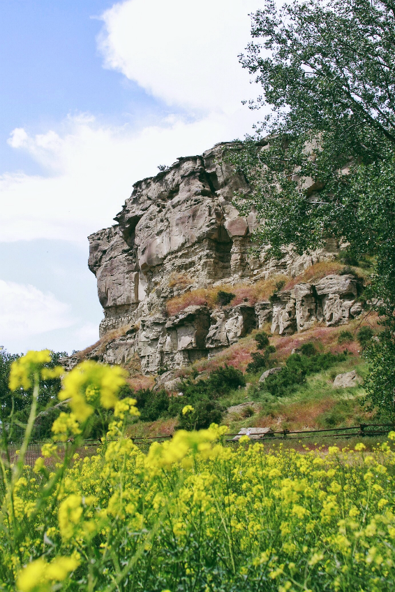 |
Pompy’s Tower
On July 25, in Clark’s group, the nine floaters noticed a huge sandstone rock “200 feet high and 400 paces in circumference” not far from the river. Clark climbed it and saw “Emence herds of Buffalows, Elk and wolves.” Indian pictographs were on the rock, and to them he added his name and the date: Wm. Clark, July 25, 1806. He named the rock Pompy’s Tower (now called Pompeys Pillar) after Sacagawea’s baby, whom she carried on a cradleboard strapped to her back for the 14 months that she accompanied and aided the expedition.
|
|
Famous Engraving A boardwalk leads to Capt. Clark’s signature and to the top of the Pillar, which is the last physical evidence of the Lewis and Clark Expedition. Trails lead visitors past a replica of Captain Clark’s canoes and to a view of the 670-mile-long Yellowstone River. In Clark’s own words, “…at 4 P.M. arrived at a remarkable rock Situated in an extensive bottom on the Start. Side of the river & 250 paces from it. This rock I ascended and from it’s top had a most extensive view in every direction. This rock which I shall Call Pompy’s Tower is 200 feet high and 400 paces in secumphrance….” |
 |
 |
Riverwalk & Interpretive Center The concrete Riverwalk, representing the Yellowstone River, begins in the parking lot and meanders through the interpretative center to the base of the Pillar. Signs along the path quote from Clark’s journals and tell of the party’s experiences from their entry on the Yellowstone on July 15, 1806, to their encampment at the confluence of Yellowstone and Missouri Rivers on August 3. The Interpretive Center opened in 2006 to coincide with the Bicentennial of the Lewis and Clark Expedition. Exhibits in the 5,700-square foot center cover the Yellowstone River Valley journey of Captain William Clark and his detachment, including Sacagawea and her son Pomp in 1806. The center also focuses on native culture, flora and fauna, the Lewis and Clark Expedition, and the history of Pompeys Pillar. A short film is featured called “About the Expedition”. |
Enjoy bird watching at Pompeys Pillar. The riparian areas, dominated by Cottonwood and Willow along the Yellowstone, are great habitat for warblers, vireos, tanagers, kingbirds, and other passerines. Great Horned owls as well as Bald Eagles and Osprey all nest either on site or nearby. The prairie to the south provides great habitat for falcons, sparrows, pheasant, and a variety of other species.
Enjoy the geological features of the Monument site. The Pillar and the cliffs across the river are composed of sandstones and shales. Although no animal or plant fossils have been documented at Pompeys Pillar, significant fossils have been found in similar sandstone beds nearby.
Directly north of the Pillar is a viewing area of the Yellowstone River, to which both trails and sidewalks lead. The Yellowstone River meanders and is the longest free-flowing river in the lower 48 states and provides rich, fertile farmland and habitat for many wildlife and bird species. The riparian areas along the river contain several cottonwood community types. Many standing cottonwood trees within the flood plain are estimated to be more than 100 years old.
Finally, for those who love a good picnic, there are tables set up throughout the monument. You are also more than welcome to place a blanket on the ground, or in one of our tipis, and have your lunch. The picnic tables are up year-round, so even if the Interpretive Center is closed, folks are still more than welcome to come in and use the area.
You can visit virtually at PPNM Virtual Tour or visit our YouTube channel at PPNM YouTube for more information. You can also view or download the PPNM Brochure, PPNM Map, or PPNM Rack Card.
Please visit on Facebook or Instagram websites for more information!
Website by